Sunday 28 May 2017

Touring The Wild Atlantic Way (Ireland) Day 8 - 12

Touring The Wild Atlantic Way (Ireland) Day 8 - 12

Wednesday 24th May 2017 - A mild windy day with occasional drizzle

We're parked up for the next few nights at the Wild Atlantic Way campsite in the village of Creeslough, and after nearly 3 weeks of abstinence we mounted our bikes again today and went out for what became quite a daunting 1st ride.  In all we managed about 32 miles, but I'd swear more than half of it was quite steeply uphill, and therefore, although the scenery was stunning it would have been unlikely we'd have made it that far without the frequent assistance of the batteries on our bikes.

We've left the Inishowen peninsula behind now and we've passed by Lough Swilly and entered the Northern part of Donegal, so our target for today was the craggy headland of Horn Head.  It lies just north of the town of Dunfanaghy and to get to it we were required to climb the narrow winding lanes that no motor home should dare to wheel over - but a few did!  However, we were sensible and climbed to the top of the huge shear cliffs on our bikes, and although it was fairly hard work we were well and truly rewarded eventually!  


When we arrived at the end of the road leading to the Head we were initially a little disappointed because the rain was starting to pitter patter and the unpaved path was to rough to take our bikes over so we really thought we were going to miss the best bit.
But as we started our decent we noticed a loop road that would take us out to a view point that actually looked back over The Horn's Head outcrop, and although it meant another episode of climbing, the effort was more than worth while for the views, and also the fast decent that provided excellent fun providing you missed  most of the pot holes!

On our return journey we also visited Ards Forest Park on the sheltered western shore of Sheephaven Bay.  It's a 480 hectare park, but other than the tarmaced road that leads down to the coast the tracks are reserved for walkers so our views of it were a bit limited.  Having said that, it was very pretty and easy ride through the rhododendron bedecked woodland, and as we had the area almost entirely to ourselves it made a lovely finish to our day.


Thursday 25th May 2017 - a scorcher!

Today the sun has shone from start almost to finish, so as we've been on the go almost constantly for the last 10 days (especially John who has driven over 650 miles), we've awarded ourselves a day off to sit in the sun and not do very much other than the scanning of our Kindles.


However, we did rouse ourselves around mid-day to go and watch the Union Cyclists International Bike Race that passed right by our campsite.  It's not quite on the scale of the Tour de France, but it's an 8 day event over 1,199 kilometres and loads of international teams take part.  As you would imagine, they flashed by very quickly but it was quite exciting to see and John even won a prize!  One of the riders chucked out his WIGGINS feeding bag right in front of us so in the interest of KEEPING IRELAND TIDY we had to pick it up!

Then it was back to the serious business of sitting in the sun - and of course, to assist us in doing that, we had to nip to the shop and buy a small amount of beverage in the form of cool cider to keep us company - cheers 🍻


Friday 26th May 2017 - another scorcher 🌞😎🌞

Today was our day for visiting Glenveagh National Park, which as usual, we did on our trusty steeds. It's one of only 6 such Parks in the whole of Ireland, and it covers 16,000 hectares of mountains, bogs, lakes and woods, and quite spectacularly, it's split in two by a valley, part of which is filled with Lough Veagh.   The park is home to a number of Golden Eagles and also to one of the largest herds of purebred red deer in Ireland, and additionally, within it's limits it encompasses two of the highest mountains in Donegal - Errigal and Slieve Snacht.

Therefore, as we peddled the 8 or so miles towards it over gently undulating countryside, we had very high expectations - and I'm quite happy to say, we weren't disappointed other than the fact that we didn't manage to see the above mentioned wildlife!   We arrived in glorious sunshine after about an hours peddling, and our first port of call was the Visitor's Centre which provided info and a map, and then next on our agenda was finding a comfy place to stop for coffee - the head of the valley proved to be perfect!


Once refreshed we took the trail that runs along side Lough Veagh, and after a couple of miles we came to Glenveagh Castle which stands atop a slight promontory jutting out into the lake.  Guided tours are available but have to be pre-booked, however we were more interested in admiring the lovely gardens that were filled with loads of multi hued rhododendrons.


After the castle the trail continued on, first towards a water-fall that spilled from the high cliff sides, and then further towards the Poisoned Glen, but as we went the track became a bit to rough for our bikes so in the end, after a lovely ride, we turned tail and went to find today's spectacular dining place.


Finally, when we'd had enough of baking in the hot sunshine we left the park and completed our ride by making it a circular one, and heading  back to the camp-site over open moorland where we saw two chaps undertaking the ancient art of cutting peat by hand.


Saturday 27th May 2017 - ☔🌧🌧🌧⛈☔ - What a difference a day makes!

This morning we left The Wild Atlantic Camp site and headed for the town of Dungloe - a distance of about 50 miles - all of which was completed in heavy rain which was accompanied by a good deal of mist and murk!  On the way we stopped off at  what is supposed to be a magnificent view point called 'Bloody Foreland' for coffee - but at the time the rain was hammering so hard on our roof we decided against getting out to take any pics!  However, we did find out a bit about it!  You'd think with a name like that it's history would include a 'bloody battle' or some other nasty incident - but no - it gets it's name from the red hue that the cliffs take on at sunset - but I'm fairly sure there'll be no 'displays' later today so we didn't hang about!

We reached our destination - a little campsite at Dungloe - around lunch time, but other than a short walk out, the rain has kept us captive for the rest of the day, but never mind - we can always make up for it tomorrow 😁


Sunday 28th May 2017 - Mostly cloudy but with some glimmers of 🌞

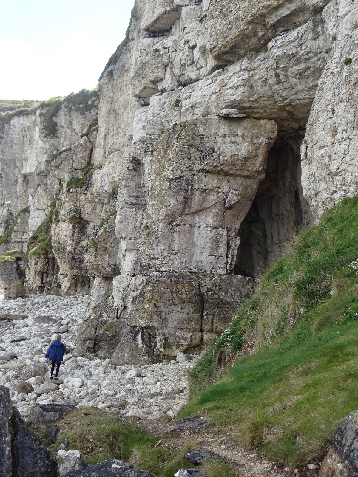
And we did make up for our 'lazy' day yesterday!  Today we deviated from the Wild Atlantic Way a bit because we 🚴 32 miles to check out two peninsulas that sit just below Dungloe - and as we went it was easy to see why this bit has been missed out!  In places the roads become very rough and little more than grassy tracks, and I say that because on our travels we've seen lots of roads where grass grows down the middle, but here it was more a case of the tarmac occasionally peaking out through the grass!  But that didn't matter to us because, even with the regular steep gradients we were fine on our bikes and the only thing we really missed was the company of our cycling buddies Sharon and Paul - we thought  they would have loved it just as much as we did!


The first part of our ride took us out towards Crohy Head and it's sea arch, and it was near here that we paused for our first break - by the time we'd done all the hills to get there we were in desperate need of replenishing our energy levels with lemon curd filled hot cross buns and coffee!  And from there we proceeded around the rest of the 'Na Rosa' (that's Irish for a piece of land that juts out into the sea) admiring not just the coastal views, but also some of the 130 lakes that this area has.


Then next came Dooey Beach which we found on  today's second peninsula and it was the place we'd earmarked for our lunch stop.  The beautiful white sand beach lies opposite Gweebarra Bay, and it's 3km length is only accessible from a little car park that lies at the bottom of a hill, and from there you have to walk along a board walk for about 100 metres before descending some steep sandy steps onto the beach itself.    However, we didn't know about the steps!  So we gallantly descended the hill and then pushed our bikes along the board walk - but only to be halted by the steps which it was impossible to get our heavy bikes down.  Therefore, our only option was to return the way we'd come - the only problem with that was the fenced in boardwalk was too narrow for us to turn our bikes round - so we quite comically ended up reversing them for the full 100 metres - I think we probably looked a proper pair of chumps!  Once back in the little car park we debated what to do next because we were more than ready for our dinner, but with no view to look at we didn't want to eat where we were.  No problem!  We just hopped back on our bikes, applied turbo mode and scooted back up the hill to find a grassy verge overlooking the bay which proved to be quite comfy while we munched our sarnies!

Once our meal was complete we started the homeward leg of our journey through more rocky lake and rhododendron filled moorland, and as we went we chatted about where our next destination should be - and as I'm writing this our target is still undecided - so to find out you'll have to read my next episode!

But for now I'll say Goodbye ✋✋ πŸ˜™


Click here to see our Irish camping spots


Tuesday 23 May 2017

Touring the Wild Atlantic Way (Ireland) Day 5 - 7

Touring the Wild Atlantic Way (Ireland) Day 5 - 7 

Sunday 21st May 2017 - Lots of rain but with some good sunny spells in the afternoon

Well, Sunday is supposed to be a day of rest, so as the rain had pitter pattered on the roof for a good part of the night, and was continuing to do so in the morning, that's exactly what we did.  We spent the morning doing a bit of planning re our continued journey, and then I pottered about and made some Stilton and Broccoli soup for lunch, and by the time we'd finished that the sun was shining!  Therefore, we decided to don our walking shoes and toddle off to visit the Glenevin Waterfall, which if we could have gone as the 🐦 flies would only have been about a mile away.  However, that would have required us to clamber over fences and to trespass in no man's land, so therefore we took the proper route which was 2.5 miles and which first took us in the little hamlet of Clonmany. And it did have many - Irish pubs - one of which we were forced to dash into for shelter from another downpour that sneaked up on us - but we weren't complaining because it provided an opportunity to sample our first pint of Guinness on Irish soil!


We sipped the delicious brew under the watchful eye of Laurel and Hardy and pondered if our drink had really been brewed in Ireland!  We later learnt that all the Guinness sold in the UK, Ireland and North America is brewed at the historic St. James's Gate Brewery in Dublin, and that it's history can be traced back to 1759 when Arthur Guinness, a 34 year old man with some brewing experience took over an abandoned brewery in Dublin - he signed a 9,000 year lease with an annual rent of £45 and began to brew - and as they say The rest is History πŸΊπŸ»πŸΊ


Anyway, back to the story, the rain only lasted about five minuets, but our beer lasted slightly longer than that, but once it was supped we were soon back out on route for the waterfall.  Unfortunately, the first part of the way was a bit uninspiring, but eventually we found ourselves walking through a pretty wooded glen beside a babbling stream that led us gently uphill to the fall itself.  Then after we'd done admiring it we set off back and decided we'd walk the extra couple of miles to see Binnion Bay, or more specifically,  Tullagh Beach.  However, this turned out to be a bit of a mistake because to get there we'd had to more or less walk right past T4rdis2, and when we arrived the heavens opened again and we were soon soaked to the skin - and this time there was no pub to dash into!  Also, a very frustrating fact was that we could actually see T4rdis2 only about 200 yards from where we were but that was across a muddy swamp area that was fenced off.  So instead of being snug and warm within our ships confines we needed to trudge another couple of miles before we were home!  Oh well, yer can't win em all πŸ˜–


Monday 22nd May 2017 - Another wet start but the day got better as we went along!

Tourist Office Aire - We're a bit longer
than the Bay!
This morning we left the Binnion Bay camp site and headed a short distance further along the Wild Atlantic Way to the town of Buncrana where the Tourist Info Office very kindly offer a free Aire for Motorhome overnight parking.  Our info had informed us that  they could accommodate vans up to 10 metres, but when we got there this was incorrect, however we did just about manage to shoe horn our 7.5 metre length into a gap with a bit of a overhang - and the lady in the office was quite happy for us to stay.  So after an early lunch while we sheltered from yet another downpour we set off to explore the area that is described as Amazing Grace Country.


John Newton
We're parked right next to a park dedicated to the remarkable story of 'Amazing Grace' which was originally composed by a foul mouthed sailor - John Newton.  He was on board The Greyhound which was sailing from Africa to England when it was caught in a violent Atlantic storm on March 10th 1748.  The ship became very close to sinking, until at almost the last moment, they found a safe haven in the estuary Lough Swilly.  The sailors were rescued and this became a turning point in Newton's life and the start of his spiritual journey.  He became a clergy-man, a prolific hymn writer and played a vital role as mentor to William Wilberforce in his historic battle concerning the abolition of slavery which was finally abolished in 1807.  However, the hymn lives on, and it's one that most people know the words too - it's topped the charts several times since it was written 200 years ago and it holds the record for the most recorded song!


Lough Swilly

Our stroll took us away from T4rdis2 and onto the 3km path that runs north from Buncrana to Stragill Strand beach, and on the way we passed an old Napoleonic Battery and also Father Hegarty's Rock - a place where Friar Seamus Hegarty was beheaded in 1711 by English Redcoats for conducting secret Catholic Masses.

After about an hours walk we arrived at Stragill beach, and it made a lovely place to sit and take in the views across Lough Swilly while we sipped our hot choc.  Lough Swilly is a fjord type inlet that is 23 miles long and named after Suili - the pagan Celtic goddess of watery places who is said to be a multi-eyed mythical beast πŸ‘Ύ!  Happily, there was no sign of her as we retraced our steps part of the way back to visit Swan Park - which has absolutely nothing to do with swans - it was bequeathed to the town by one Harry Swan in 1965, hence it's name


To get to the park we walked beside the rushing torrents of The River Crana and through a wooded glade that was festooned with little fairy hides - they were very cute!  But by then the skies were darkening again so we decided to try and dash home via one or two shops for several little essentials - but we needn't have hurried cos almost without a drop of rain falling the evening finished with glorious sunshine.


Tuesday 23rd May 2017  - A dry but blustery day

This morning we left our free spot at Buncrana and set of to drive around the Fjord of Lough Swilly, first to the town of Letterkenny, and then up the other side through the hamlet of Rathmullan, and further on into the mountainous hills towards Fanad Head.  However, as we advanced along that side of the Fjord the narrower and steeper the roads became, and for much of the way we were on single track roads which required T4rdis2 to breath in every time we came to another πŸš—πŸšœπŸšŒπŸš›.  Having said that, both T4rdis2 and John managed with great aplomb  and I only very occasionally had white knucklesπŸ˜“, but nevertheless, when we finally came to a road with a white line down the middle John's face lit up as if he'd been given a great big fat 🍦and I breathed a big sigh of relief - and we never did get as far as the lighthouse at Fanad Head!


We did however manage to pass over the Knockalla Mountain, and as we traversed it's downward slope we pulled into a view point overlooking the beautiful Ballymastocker Beach, and as our spot was so stunning we decided to stop for lunch even though we were on quite a 'wonk'!  Therefore, my challenge was to cook fired eggs without them all settling in one side of the pan!


While we were there we also learnt about the HMS Saldanha - a Royal Navy Warship that was based in Lough Swilly and patrolled the seas against attack from Napoleon.  She was lost in 1811 after setting sail with HMS Talbot and running into a fierce storm that forced the ships to turn back.  Sadly the crew of HMS Talbot witnessed Saldanha's last moments as she hit the rocks and was  swallowed by the waves as her hull broke in two.   Many of those who escaped died in the freezing water and over 200 bodies were washed up on the shore thus this was declared one of the worst disasters in Irish Marine History.

When we left our lunch spot T4rdis2 still had a bit more mountain 🐐 impersonating to do, and then about an hour later we eventually arrived at our home for the next 4 nights - The Wild Atlantic Campsite - where with a bit of luck we may be giving our bikes some much needed exercise!

But that will a sequel to this πŸ˜™πŸ˜™

Click here to see our Irish Camping Spots

Saturday 20 May 2017

Touring The Wild Atlantic Way (Ireland) - Day 2 - 4

Touring The Wild Atlantic Way (Ireland)  - Day 2 - 4

Thursday 18th May 2017 - A mixed bag of lovely warm sunshine and heavy squally showers!

Today our plan was to visit Carrick-a-Rede and Larrybane Quarry - an area that belongs to the National Trust, and one where a rope bridge can be found that can trace it's history back for 350 years.  The site was only about a mile and a half from our campsite, so as usual, our picnic was soon packed and off we went on πŸ‘£πŸ‘£πŸ‘£ heading for our goal - but at that stage we did wonder if we'd be able to complete our visit because to keep numbers under control in this beautiful area the Trust run a ticket entrance system and only so many are available each day.  However, we needn't have worried because when we arrived it wasn't really very busy at all and we just sailed straight in!

The name of the place - Carrick-a-Rede - means rock in the road - the road being the old sea route for Atlantic salmon on their westward journey past Carrick Island.   History has it that for over 350 years fishermen in the area strung a rope bridge 30 metres above the sea to allow them access to the best places to catch the migrating salmon that were making their way back up stream to spawn.


Apparently, on a good day the fishermen might expect to catch as many as 300 fish, and then balancing their catch on their backs and holding on with one hand they would venture back over the swaying bridge.  Sadly the salmon have disappeared now so these days all that is left are the 'stories', a new rope bridge and the breathtaking views that people come to see.

The signboards here challenge you to follow in the foot-steps of the salmon fishermen and feel the sway of the new rope bridge that is suspended almost a hundred feet above the crystal clear blue/green sea - and that is exactly what we did - but the rocking motion made for a white knuckle grip as you crossed, and glancing down almost made me become unbalanced!


Once we'd gained the far side and were safely on Carrick Island we took our time exploring the high cliffs that were festooned with nesting birds, and we even managed to find a deserted spot to sit and sip our coffee while we watched the ocean waves crashing up onto the cliff faces.


We made our return journey via the same route across the bridge, but on the way back we learnt another interesting fact - the bridge crosses the mouth of an ancient volcano!  As we looked back towards the mainland we could see dark rock forming a wide vertical pillar up through the white chalk - this was basalt or cooled lava that had erupted from the Carrick-a-Rede volcano over 60 million years ago!

By now, as it was nearly lunch time so we were on high alert for spotting a comfy dining area and this we found a short distance away within the confines of the now disused Larrybane Quarry.  Here we discovered towering lime stone cliffs where crags and cracks abounded, and it was within their shelter that we nibbled our sarnies as a squally shower passed by. This area was also used for some of the filming of Game of Thrones, and as we later stood on the cliffs above it was easy to imagine the marauding hordes battling  in these surroundings!


NNext, our walk took us onwards into Ballintoy Harbour where we treated ourselves to ice-cream while we sheltered from another squall!  But it was absolutely no hardship to pass the time there because the views out over the the ocean with its numerous basalt stacks that in the past have contributed to making these waters treacherous was mesmerising as the tide started to race in.

And then finally, all that remained was for us to retrace our steps back the way we'd come with our fingers crossed that we could beat any further rain showers home.


Friday 19th May 2017 - Mostly warm and sunny in the morning but with a few showers in the late afternoon.

This morning we left The Glenmore Hotel Campsite and headed for The Giant's Causeway - another National Trust Property, and one that is said to be a Geological wonder that is steeped in legend and myth!  We arrived about 11am, and once again we seemed to be ahead of the crowds which added to our pleasure of exploring this magnificent place.


We entered the UNESCO World Heritage Site through the visitor centre which has been designed to blend into the landscape with it's walls of glass, grass roof and basalt columns, and it blends  in so well that it almost disappears when observed from the coast side.  Once inside we found loads of interactive 'toys' and displays that informed us about the geology and science of the area, and while we were there we discovered that the 40,000 interlocking hexagonal basalt columns that the Giant's Causeway is made up from are the result of intense volcanic and geological activity which took place 60 million years ago, and that some of it's uniqueness is the result of the cooling and shrinking of successive lava flows.

However, I found the other 'stories' more entertaining and these were expanded upon by the Audio Guide that accompanied us on our walk. The tales were mostly about the gentle giant Finn McCool who stood a mere fifty two feet six inches tall - a relatively small giant!!!  But across the sea in Scotland there was a rival who was much bigger and his name was Benandonner.  The tale tells how the two giants hollered across the sea of Moyle, each demanding a trial of strength.  This was agreed upon, and Finn offered to make the contest possible by building a rocky causeway between County Antrim and Benandonner's lair - Fingal's cave on the island of Staffa. However, the work was hard and Finn fell into bed and slept heavily from exhaustion, but early the next morning Finn's wife Oonagh  was woken by the sound of thunderous footsteps and she knew she would have to think quickly to save Finn!  She covered him with a nightgown and bonnet, and then told Benandonner 'to be quiet or you'll waken the bairnπŸ‘Ά'.  At this Benandonner panicked!  If the child was this big, how much bigger might Finn be?  He hastily retreated across the causeway, ripping up some of the stones in his wake! And I suppose after that they all lived happily ever after!

We really did enjoy our visit and as we meandered we took the time to scramble over some of the Causeway itself, as well as viewing the many rock formations which included The Camel, The Giant's Granny, The Organ (which is said to be played by Finn at 6am every Christmas Morning), and The Boot (size 93 and a half!)


The site also offers 4 walking trails which are graded from easy to challenging - we chose the
red difficult one, which once we'd climbed the 162 steps of the Shepherd's Staircase offered us panoramic views of both the Causeway and the Wider World Heritage site.  And it was as we were climbing that we learnt about the 'Kelp'  In times gone by the seaweed was gathered by women and children for the extraction of it's minerals and also to be sold as fertiliser.  But once it had been collected it had to be transported up the cliff face to the road, and apparently this was done by the women who carried large quantities of it balanced on their heads - but that was in times before the stairway had been installed. Those poor souls had to scramble up the almost perpendicular cliffs unaided!

After our visit we debated what to do for lunch - should we stay in the car park with it's limited views or should we drive on and see if we could find somewhere better.  The latter won and the road led us though the town of Bushmills which is famous for it's whiskey, and then on past the atmospheric ruins of Dunluce Castle which stands overlooking the ocean.  And immediately after that a perfect dinning room presented itself in the form of a picnic site high above the crashing waves, so that was where we sipped our tomato soup along with some freshly baked dunking bread - perfect!

Then it was forwards and onwards into The Republic of Ireland and to tonight's resting spot which was a deserted (and free) car park just above Stroove  beach - a place we found using our  Camper contact app.


Saturday 20th May 2017 - Mostly a lovely sunny day but with 2 torrential downpours!

Our Wild Parking spot at Stroove Beach
This morning we were a bit undecided what to do - should we go for the 8.5 km walk to Inishowen Head  or should we settle for a shorter trek to Port-a-Doras - a small portal through what at first appears to be solid rock.  We opted for the latter, mainly because there is a distinct lack of parking places and campsites in this area, and as we were unsure where we'd be resting tonight we didn't want to linger to long here.

We left T4rdis2 in the car park and strolled first through a field full of noisy sheep, and then following a vague rough path we traversed along the rock strewn shore line until we came to a large outcrop that seemed to be blocking our way.


However, here we found the small natural doorway in the rock that led us into an amphitheatre pebble beach with high towering cliffs on 3 sides and the ocean on the 4th, but that direction was guarded by about a dozen Cormorants on sentry duty!


The beach was really quite breathtaking mostly because of the many weird rock formations that the elements had carved over the millennia - if you used your imagination you could almost make them into seals or mermaids basking in the sunshine!

However, that episode of sunshine didn't last long, and on our way back we got lashed by the rain as the first heavy squall of the day passed over!


Next on our agenda was Malin Head and Banba's Crown - a place we ended up visiting twice!  Malin Head is Ireland's most northerly point and lies at the very tip of the Inishowen Peninsula and can only be reached on foot.   To get there most people park at Banba's Crown - a hill with an old signal tower at the top which was built by the Admiralty in 1805, but it also has several other claims to fame!  It is the place where folk stood to wave goodbye to their loved ones as they set out across the sea to a new life in America, and more recently, the huge word EIRE has been set out in white stones on the grassy slopes so that World War 2 pilots knew they were flying over neutral territory.  Also Malin Head has a long history in relation to communications - it was through here that news came of the American Gold Rush in 1848 and of the shooting of President Lincoln in 1865, and today many would know it for it's shipping forecasts.

But why did we visit twice?  Well the first time we followed the route we went up in T4rdis2, but as the road became narrower and steeper we became a little worried, and then when we got to the top the small car park was closed resulting in cars being littered into almost every small space available!   And their was definitely no room at the inn for us to park our rather large ship, and neither was there much room for John to turn us round.   However, in the end he found a small gap, and almost on a surface no bigger than a shilling, round we spun!  So then we had no choice other than to trundle back down the hill and to retrace our tyre tracks for about 2 miles to a parking space we'd spotted earlier.  By now it was lunch time so we ate our sausage sandwiches while gazing at the rugged coast with it's myriads of birds searching for theirs!

Then it was back up the hill but this time on πŸ‘£πŸ‘£πŸ‘£!  We once again passed through the busy area of Banba's Crown and then we continued on down a track that led us past  the wild and windswept dramatic cliffs that lead up to Malin Head itself.  Apparently this part of the coast has some of the most treacherous waters in the world and it's been the site of over 400 ship wrecks in the past, and when you see the jagged crags rising up out of the water that really isn't much of a surprise!

But what was a surprise was the fact that some of the Star Wars Episodes had been filmed in this area and that the Millennium Falcon had been reconstructed and perched on the cliffs here in this isolated location.


All too soon our time here was done and we needed to potter back to T4rdis2 and start looking for a spot to rest our weary heads.  This presented itself in the form of a strange but lovely little campsite at Binnion Bay, but once again, to get there we needed to travel along more narrow lanes with our fingers very firmly crossed that we wouldn't meet anything coming the other way!  It would be so much easier if this T4rdis could dematerialise like it's namesake!

Anyway, that's our story so far and I'm going to publish this blog quick while our Wifi is holding out because here in this part of Ireland it's a bit like hen's teeth πŸ˜πŸ˜™

Thursday 18 May 2017

Ireland - Here we Come!


Ireland - Here we Come!

Sunday 14th May 2017

Today was to our last day at the Butterley Bank Camping and Caravan Park, and even though it's very basic it's served us extremely well with regard to it's lovely rural setting and it's location in relation to our family.  Also the owners have been very friendly so if they manage to plumb in electric (as they plan to) we'll certainly be back and hopefully we'll be able to call the site home when we visit our roots in the future.


We spent today preparing T4rdis2 for our forthcoming jaunt to Ireland but that didn't really take very long, so we also managed to squeeze in a bit more visiting which included Sunday Dinner with Ben, Louise and Evelyn - a visit which was made much easier because John and Val (sister and brother-in-law) lent us their car - so a very big THANK-YOU to them πŸ˜™πŸ˜™


Monday 15th May 2017

This morning dawned very dreary and instead of the bright sunshine we'd got used to, rain greeted us when we threw back our blinds, but as we knew we would be spending most of it driving the 308 miles up to Scotland it didn't really matter other than for the fact it would make driving conditions less than perfect!

We left the site at about 10am, fuelled up and then we were soon on the motorway and gobbling up the miles - however on several occasions T4rdis2 was unable to 'gobble' as quickly as we would have liked because the traffic was heavy, and in all our journey took us over 8 hours!  Therefore we didn't arrive until 6.30, and after driving all that way in heavy traffic and sometimes teeming rain, poor John was feeling the strain so we did no more than park up in the Ferry Terminal Car Park at Ardrosson, had a quick tea, and then chilled for an hour before bed!  But even that didn't prove to be a 100% restful - there was a bloody great ⛴ berthed at the side of us which ran it's generator all night, and then at about 5 am a 🐦(seagull) 🐦 decided to come and do a tap dance on our roof - and not only was he wearing hob nailed boots, he also screamed for his mates to come and join him!  I think it's safe to say we were quite glad when morning came!


Tuesday 16th May 2017

Today was a bit of a special day - we're celebrating a year of living within the confines of T4rdis2 πŸŽ‰πŸŽ‰πŸŽ‰

So for our special day our plan was to nip over The Firth of Clyde to the  Isle of Arran to see John's sister Cath and her Husband George - it was lovely to see them both again after over a year, and from the minute we got there they worked very hard at spoiling us!  First it was back to theirs for coffee and catch up, then they treated us to a fine lunch at The Douglas Hotel, then more indulgences in the way of posh chocolates form the hand made Choc Shop, and after all that we took the time to sit on the sea front in lovely warm sunshine while we nattered some more and watched the yachts bobbing about in Brodick Harbour!  We finished our visit off with coffee and cake, but all too soon it was time to dash and catch the ferry for our return journey to T4rdis2 who had patiently waited for us in the car park!

And really it was a good job we hadn't left it too late to come back over the water because we still had a 50 mile journey up to Lendalfoot where we overnighted in a  lovely parking area that is home to The Russian Varyag Memorial.

The memorial is  situated here because in 1920, after serving in the Russian Navy, the Varyag was sold to Germany for scrap, but while she was under tow she ran aground on the rocks off Lendalfoot and this became her final resting place.  The wreck remained visible until 1925, but then the once proud warship sank beneath the waves.

Our parking spot was only a few metres form where the Clyde's waters  lapped over the shore line rocks, and the icing on the cake was the magnificent sun set that occurred as we were eating our late tea - if this had been a camp site I'm sure it would charge premium rates, but we're in Scotland now so it was all free!


Wednesday 17th May 2017

What a wonderful way to start our day - we unlatched our blinds and the view out over the waters to The Isle of Arran that was festooned in cloud was quite breath-taking - a fantastic spot to sit and enjoy breakfast!  However, we didn't have to much time to linger - we were soon pottering on our way to the Cairn Ryan Ferry Port ready for our departure for our next adventure.

Our crossing was calm and quick - only 2 hours - and then we disembarked onto Irish soil and our first drive along the magnificent coastal road which took us tonight's destination which was to be The Glenmore House Campsite.  The site is situated between Ballycastle and Ballintoy and we've specifically come here to visit The Carrick-a-Rede Rope Bridge and The Giants Causeway, so all we have to do now is hope that the weather is kind to us so we see them in their best light!


Oh, and did I mention the dreaded midges - as we got here the heavens opened - but the downpour didn't last for long!  The sun quickly came out resulting in mist rising from the dampened ground, but because the air was very still this allowed the midges to rise in great numbers and some of them manged to sneak stealthily into T4rdis2's interior around our insect nets resulting in John and I swotting every-which-way in the hope that we could rid ourselves of them before bedtime - we didn't want to become their feast overnight!!


Anyway, that's about all until next time  πŸ‘‹πŸ‘‹πŸ‘‹πŸ˜šπŸ˜š