Showing posts with label Ireland. Show all posts

Wednesday, 12 July 2017

Touring The Wild Atlantic Way (Ireland) Day 53 - 57

Touring The Wild Atlantic Way (Ireland) Day 53 - 57 

Saturday 8th July 2017 - A warm and mostly sunny day.

This morning we left Skibbereen via Lidl and headed off towards the last section of The Wild Atlantic Way - and would you believe we actually had a proper plan - however, as often happens, it didn't quite pan out!  We'd spotted a WildCamp spot (on the Camper Contact website) on the lovely sandy shoreline of Coolmain Strand, but when we got there the parking area was rough and nearly full, so there was no room at the Inn for T4rdis2's major proportions!  Therefore, we had no choice but to continue on along the road that hugged the shoreline, but as we went we kept our fingers crossed that another place would turn up - and it did!  T4rdis2 managed to slot in with a couple of other motorhomes on a bit of high ground overlooking the ocean and with the Blue flag beach of Garrettstown on one side and Garrylucas beach on the other.


It was a perfect (and free) place from where we could watch the tide tracking in and out, and from where we could take a walk out onto the peninsula of The Old Head of Kinsale.   This peninsula is one of the longest in Ireland and sticks out about 3 miles into the sea, but the far end is almost cut off from the mainland by a narrowing in the middle, and unfortunately this is the bit that's inaccessible because it's a privately owned by a golf course. However, what we saw was very beautiful - we thought we'd already seen all the best bits of The Wild Atlantic Way, but as we go it just keeps giving more!


While we were walking John went off looking for a big sea cave that we'd read about in our guide book.  Now bear in mind that the book had informed us that it was only accessible at low water, and at the time of our walk the tide was rushing in!  So when we spotted a
carnivorous  cavernous opening he had to be quick in checking it out - however, the cave we found turned out to be a bit of a tease - and we never did find the real thing!


Anyway, after that little exertion the next thing on our agenda was tea, and really we had two choices! It could either have been a bit of garlic with some of the many snails we saw while we were walking, or as we were sat overlooking the Wild Atlantic - we could have Atlantic salmon - no competition really - the latter won flippers down!

The Moon Falling into the Sea!


Sunday 9th July 2017 - Warm and sunny to start but a cloudy evening.

Today's been one of those days where there really isn't much to say!  We left our sea view perch and quickly bid a sad farewell 😒😒 to The Wild Atlantic Way as we headed off across Ireland's southern coast towards Cork and our final campsite of this tour.  We landed about lunch time at the packed Casey's campsite near the town of Dungarvan, and since then we've been quite lazy and just lozerked about in the sunshine!  We're saving ourselves for tomorrow when we plan to ride along a big chunk of the Waterford Greenway - a 46 kms off road cycle-way that  claims to be spectacular - we'll see!


Monday 10th July 2017 - Only glimpses of sun today and a massive downpour in the early afternoon!

John - Happy Birthday to my Soul Mate - Love you xx 

Now, most people on their birthday's choose something like taking it easy, putting their feet up and maybe going out for a little treat in the evening - but Oh No.  Today, for his amusement John chose a 43 mile bike ride - but I suppose I ought to look on the bright side - at least there were no big hills!

Our aim was to ride along some of the Waterford Greenway - an old railway line from Dungarvan to Waterford City, but we knew we wouldn't make it all the way because that would have resulted in us peddling 57 miles (there and back), and that would just have been a wee bit too far! So we made our target Kilmeaden, and along the way there was plenty to see.


First came a section that was elevated above Dungarvan Bay which provided lovely oceanic views, and soon after that we found ourselves on Ballyvoyle Viaduct - but because of the lay of the land and because we were on top of it we didn't manage to see any of it's old architecture!  Next came the Dark Dark Ballyvoyle Tunnel - a 400 metre burrow like structure that entered into the earth and seemed to swallow us up,  and a place that allowed our voices to echo around atmospherically!


And then as we exited the tunnel we found ourselves in a leprechaun glade - there were lots of little doors to the caves where the little guys lived and thrived - but we thought they must all be on 'night duty' cos we didn't see anybody pottering about!

Our ride then traversed through pretty valleys with views of the Comeragh mountains to the north, and it also took us over our second viaduct of the day at Durrow. Here we found the ivy clad ruins  of the old Durrow Station where the platform and waiting rooms still stand - but we were a bit disappointed - because although a lot of care had been taken to deck the area with flowering tubs etc - there wasn't a bench or any where to sit in sight!

Therefore, we pressed on through lush countryside until the old Famine Workhouse at Kilmacthomas (which dates back to 1850) came into view.  And at this point we spotted a pretty little park area so we couldn't decide weather to stop for lunch or press on to our ultimate goal - Kilmeaden.  We did the latter but wished we'd done the former - Kilmeaden is the home of the Waterford and Suir Valley Heritage Train - but it only runs for 500 metres - so definitely not one of 'The Worlds Great Train Journeys', and the place was heaving!

So once we'd had a little look around we turned tail and headed back to the garden area at Kilmacthomas where we just managed to scoff our lunch and get going again before the heavens opened!  We were soon soaked through to the skin, and the rain came so heavy it was difficult to see where we were going at times.  But luckily it only lasted for about 10 minuets, so after that we upped our power to 'Tour' and dried ourselves off in the 15 mph breeze we created as we dashed along!

By the time we got home we were mostly dry, but it was a good job we'd hurried as the rain just kept coming for most of the evening after that.  But it really didn't matter to us because we didn't stir out of our door again - instead we flipped the cork on a bottle of 🍷🍷 and shared a lovely home cooked steak dinner with apple pie and custard to follow!


Tuesday 11th July 2017 - rain, rain and more 🌧🌧🌧🌧🌧☔

Today we were once more kept captive inside the comfy confines of T4rdis2!  We had planned to go out for another ride - or maybe a walk as this was our last full day in Ireland!  But we thought it really wouldn't have been much fun in the rain, so we stayed put, and maybe it was a good thing really, cos John's got a lot of driving to do over the next couple of days, so a day of rest is possibly just what the Doctor ordered.  And me - instead of resting I cooked and  baked!  Carrot and coriander soup, cherry cake, flapjack, and then sticky ginger and orange chicken for tea!


Wednesday 12th July 2017 - Lots of lovely sunshine.

Would you believe it?  Yesterday we were stuck indoors all day cos of the rain, and today when it would have been lovely to go out, we've got to travel!  Our ferry from Rosslare to Fishguard isn't till 6pm but we needed to be off the campsite by mid-day or we would have had to pay a late departure fee.

Therefore, with only a 70 mile journey to cover we had plenty of time to spare - and we thought we'd be able to spend it on Rosslare Strand/Beach - but over here the children break up earlier than in England and the holiday season is in full swing now. Additionally, as it's a lovely day everybody was making the most of it, so there were no T4rdis2 sized gaps for us to park in when we got there.  So round we spun and we eventually found a pretty little lay-by with flowers, a stream  and πŸ„πŸ„πŸŽπŸŽ grazing nearby - and although it would have been nice to be beside the sea - our spot made a handy resting place until it's time to go to the Port for our departure back to Blighty.

So from us it's goodbye for now from Ireland, and we'll see you again soon when we're back on 'home' territory! πŸ˜™

PS. Happy Birthday George xx


Click here to see our Irish camping spots

Friday, 7 July 2017

Touring The Wild Atlantic Way (Ireland) Day 49 - 52

Touring The Wild Atlantic Way (Ireland) Day 49 - 52

Tuesday 4th July 2017 -  Fine all day but with heavy cloud and very misty in the late afternoon.

This morning we left the Berehaven Golf Club on the Beara Peninsula and headed for Mizen Head on the 5th and final finger of this part of The Wild Atlantic Way.  However, in so doing we missed out the fourth Sheep's Head finger - partly due to lack of time and partly because the road system didn't seem to be suitable for T4rdis2.

Our first stop was just outside the town of Bantry where we overlooked the 'Blueway' (starting point for three kayak trails) on the seaward side and the Abbey Cemetery rearing up in front of us, and here we had a bit of a history lesson.


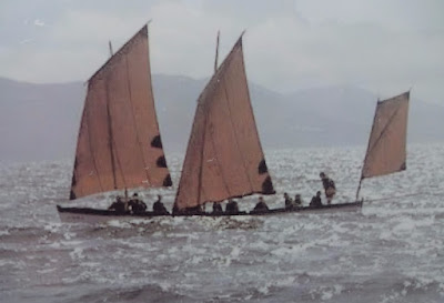
First, we learnt about the origins of the long boats that take part in The Atlantic Challenge.  In December 1796 a French Armada of 48 ships and 13,000 troops under the command of General Hoche tried and failed to land at Bantry due to adverse weather conditions.  Most of the Fleet returned to France but a ship's longboat and her crew were washed ashore on Bere Island. The sailors were quickly apprehended by local yeomanry and the longboat was abandoned in a boathouse at Bantry House - and there it lay for 150 years until it was presented to the National Museum of Ireland.  Then in 1980 an organisation called Atlantic Challenge International began building and racing replicas of the 38 foot Bantry longboat, and now over 16 countries with 70 replicas of the original take part in the biennial Atlantic Challenge Contest.

The other thing we learnt about were some more heart rending facts about The Great Famine that lasted from 1845 - 1847 and during which time over a million people starved to death and another million and a half emigrated. The info boards told of the terrible living conditions in the area 'poverty, disease and filth everywhere with all the main roads into the town being lined with hovels' - and into that situation came  the dreaded 'Blight' which is described as ' the greatest catastrophe ever to befall this country'.  

The potato was the only food for the vast majority of the Irish population and Bantry and Skibbereen were two of the worst hit areas - thousands died locally of malnutrition, fever and starvation even though enough corn, beef, butter and pork were exported ' as would have fed the entire population of Ireland'.  The catastrophe happened because throughout Ireland the land was held almost exclusively by absentee landlords who leased it to middlemen, who in turn divided it and let it to farmers.  The farmers divided it again and sublet small patches of about an acre to cottiers and labourers, and on this they would build a hovel and grow potatoes.  An adult would eat from 7 to 10 pounds of them every day - so a family of two adults and four children would get through a total of six tons a year which was the amount one acre could produce!

The inscription on the 10 foot cross reads
'To mark the famine pits of 1846 - 1848 
May God give rest to the souls of the faithful departed'
In 1847 a 23 year old doctor called Joseph Kidd came from London to Bantry to assist and he wrote 'In every hut every inmate lay abandoned to their fate, fever and dysentery side by side on the same scanty pile of decomposed straw or on the cold damp earthen floor without food or water.  There were cabins where dead bodies lay beside others barely still alive'


The graveyard we were looking at was that of an Abbey where some of the famine victims were buried in huge pits - now marked by a tall cross.  Outside the town whole families were often found dead in their hovels, and when this happened the cabin was sealed and became their family tomb!


Once we'd absorbed all this info we continued our journey towards Mizen head, but on the way we passed by the unbelievably beautiful Barleycove beach.


Unfortunately we couldn't get very close because the car-parks were guarded by height barriers, but from the hillside above we could see the lovely white sand bay that was surrounded by gently sloping hillsides and dunes with the pale blue ocean gently lapping on the shore.

T4rdis2 overlooking the very misty Atlantic
And from there (about 5 miles to go) our onward journey became a bit more exciting - the roads became narrower, bumpier, twistier and in places steeper - and when a big lorry came around a corner barrelling quickly towards us I let out a little shriek of fear!  However, I needn't have worried because my trusty driver just popped us into reverse and drove backwards for about 100 metres to a passing place that just allowed the lorry driver to scrape by!  Luckily after that we didn't meet any other 🚌 or πŸš› so we were soon settled in the large parking area for Mizen Head where we planned to spend the night!


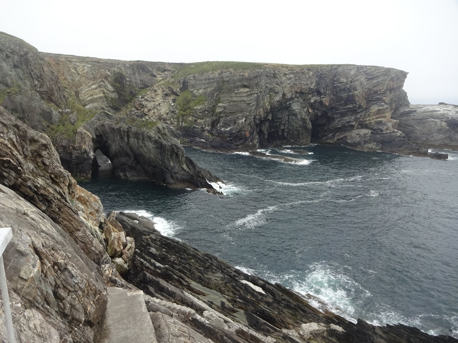
And really I think Mizen Head's story is best told with photos - although it would be impossible to do this wild bit of coast justice even if my name was David Bailey!


Mizen head is the most southwesterly point of Ireland and it's described as giving 'an edge of the world feeling' - and without the provision of The Footbridge, along with the many walkways and staircases it would probably be inaccessible to most people.

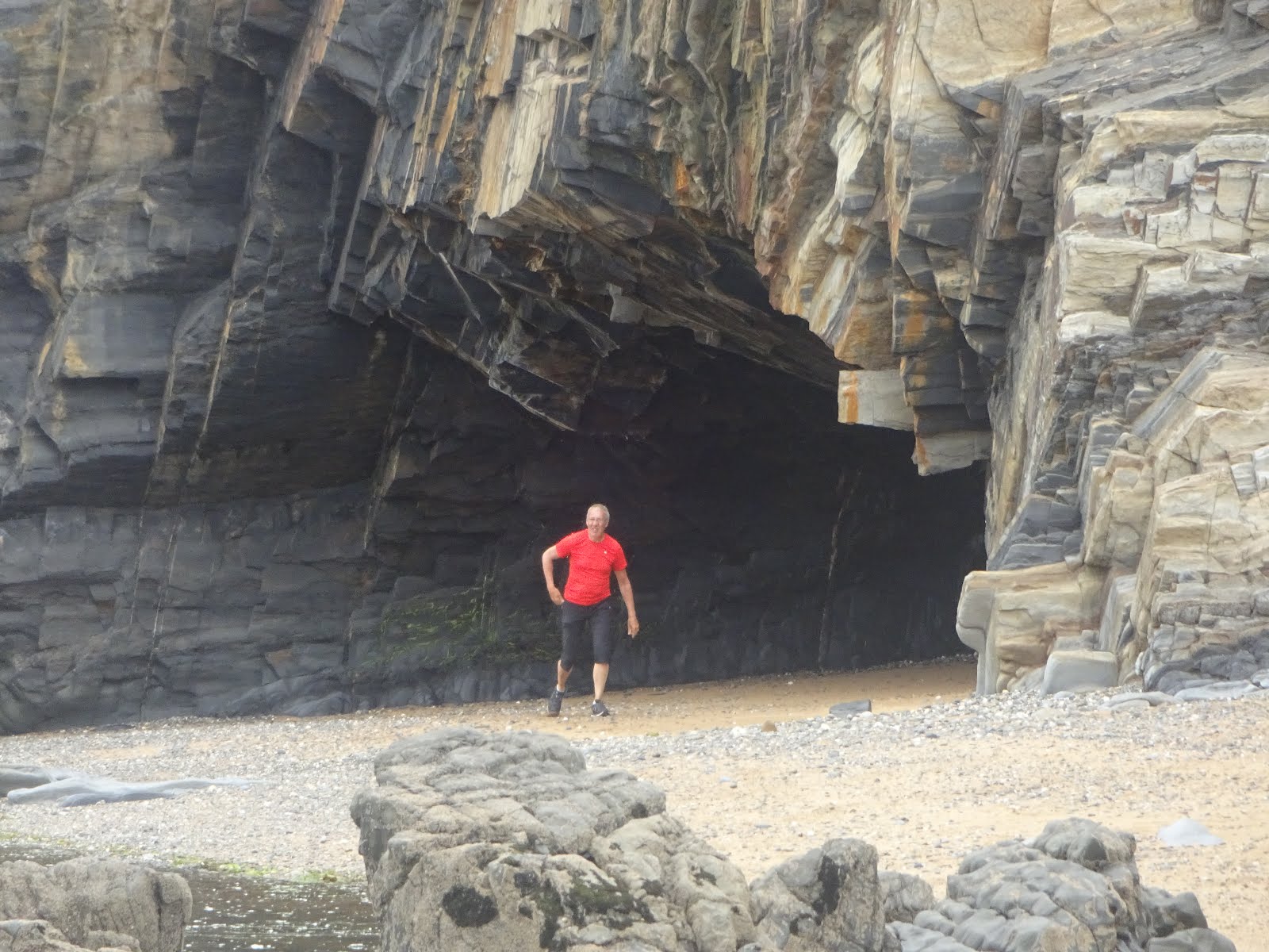
Therefore, we didn't mind paying the small admission fee to cross the bridge and explore the magnificent cliffs that have been contorted by the action of the waves.  Really the only way our pleasure could have been enhanced would have been if the weather had been better - while we were there the mists rolled in, and had we arrived any later many of the stupendous views would have been obliterated.


The hazy bit at the top is the fog rolling in!

John says we climbed over 300 steps all told!

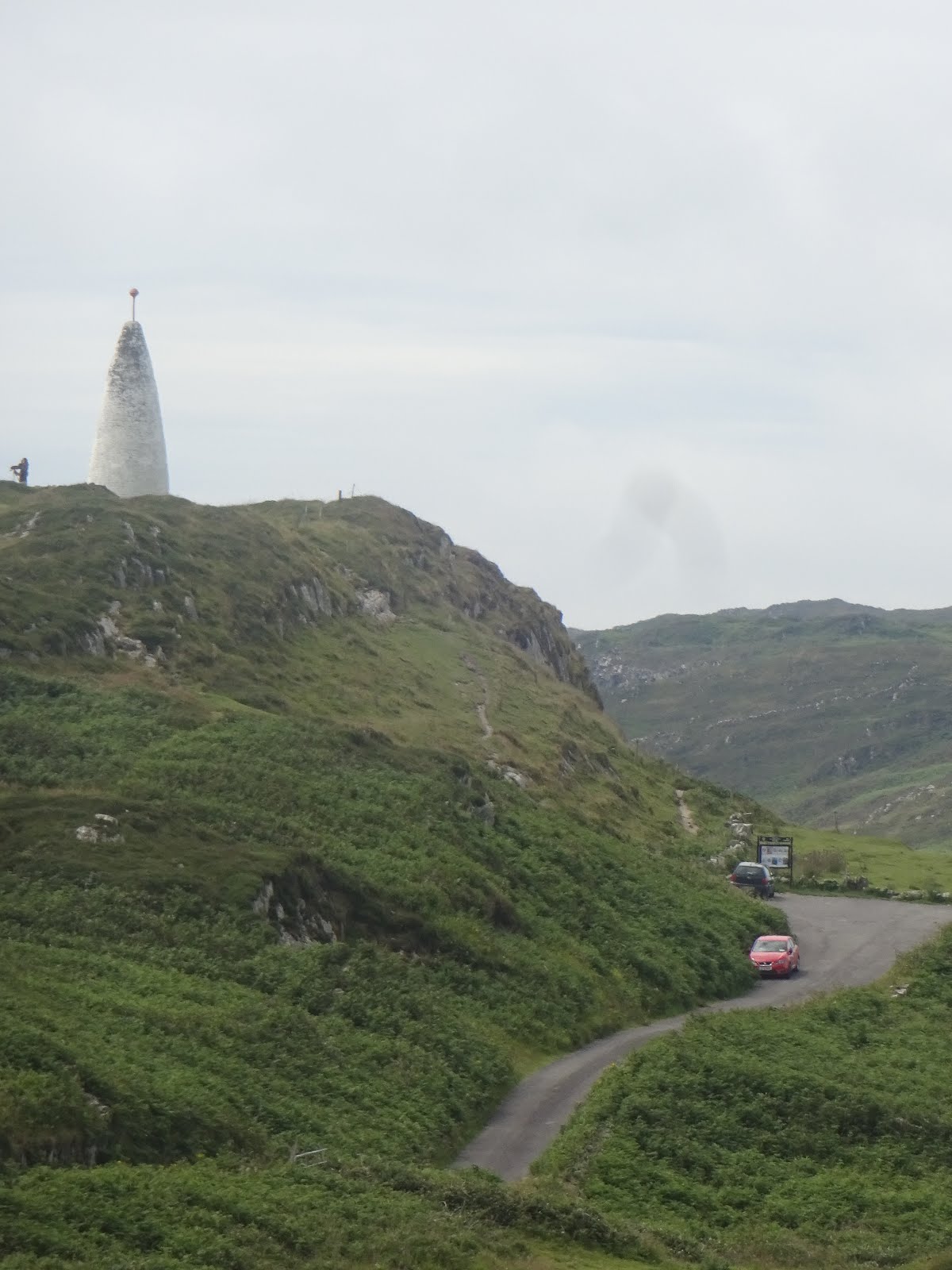
Mizen Head Signal Station was built in 1909 and was originally just a fog signal station - and even though a light was added later there has never been a proper lighthouse here.  The light is mounted in the open on a freestanding pedestal, and forming a backdrop to it is a 4 metre octagonal concrete structure.  Nowadays, the buildings house an award winning Maritime Museum and Heritage Centre that provides a fascinating history of the area that includes a lot of info about  ships that have been lost on the rocks.


One of the other things that was presented while we were there was information about Fastnet and it's Lighthouse.  The Fastnet Rock is the most southerly point of land in Ireland - and on a clear day it would have been visible from Mizen Head - but it certainly wasn't today!  The lonely outcrop is locally known as the Teardrop of Ireland - as it was the last bit of Ireland that emigrants would see on their long trip to America.


The lighthouse that stands on the rock now is said to be one of the best designed beacons in the world, but it isn't the only one that has been situated there.  The first one was built in the 1850s but it wasn't considered robust enough.  The current tower is built of Cornish Granite, and for it's time (early 1900s) it was an incredible feat of engineering.  Construction started in England in 1899 with 2,074 numbered blocks (weighing up to 3 tons each) being assembled into the tower as a practice run.   They were then disassemble and brought to Ireland where the process was repeated on the Fastnet Rock.  Apparently the whole process took 5 years, and since then it would seem likely that the lighthouse has saved countless lives.

Part of the Chasm that the Bridge Crosses

Once our visit was complete we retired back to T4rdis2 where we had hoped to do a bit of wave watching as we are parked well above the ocean on the South side of the peninsula.  However, even though the sea is only a few metres away it is almost obliterated by the dense mist and very little is visible!  Maybe it will be better in the morning!


Wednesday 5th July 2017 - Pea Soup in the morning but brightening to a lovely sunny afternoon!

If anything the fog got worse overnight, so by this morning visibility seawards was almost non existent, and the road way wasn't much better.  However, we wanted to get down the twisty turny hill  before any tourist coaches started to ascend so an early start was in order.

Our first stop was just outside the village of SchullπŸ’€- not named after the cranial appearance of the mountain behind it but for the medieval monastic school that once stood there!  But we hadn't really stopped off to see the  village - a little beyond it was the Toormore Alter Wedge Tomb that dates back to about 3,000 BC.  It's built from local slabs and is one of a dozen on the Mizen peninsula, and it's said that it's entrance was deliberately lined up with the distant Mizen Peak. Apparently people have worshipped here since it's origins, but more recently in the 18th century Catholic priests said mass here when it was illegal to conduct the services in church.

Our next stop was the hamlet of Ballydehob where we found another accepted 'WildCamp' spot on their mostly disused harbour.  It really was a pretty little place right on the water's edge of a small estuary, and had it been later in the day we may well have called it home for the night.  However, it was only about mid-day so other than a quick stroll around we were soon on our way again - but we did catch this chap taking a pic of their 12 arch disused railway bridge.


From there it was forwards and onwards to our final resting place for the next few nights - The Hideaway Campsite at Skibbereen.  The site is quite pretty but the town itself turned out to be a bit of a dump disappointment in it's unkemptness - but as we plan to cycle out of it on both full days we're here it really doesn't matter!


Thursday 6th and Friday 7th July 2017 - Both days warm with lots of visits from Mrs Sun!

Happy Birthday Vicky - Hope you had a lovely birthday 'holiday'
πŸŽ‰πŸŽˆπŸŽ‰

We've spent the last two days cycling around this last part of The Wild Atlantic Way, and really our time here has probably served as a bit of a wind down as our Irish tour is coming towards it's end.  This part of the coast is less dramatic than some of the other counties, but in it's own way it's very beautiful with loads of little coves, and bays, as well as an abundance of small islands dotted about just off the coast.


On Thursday we headed  first for the very peaceful Lough Hyne, and then continued on to the town of Baltimore where we spotted a cafe offering 'Cape Cod 🐟 and chips - but on this occasion we didn't indulge!


Lough Hyne is one of Ireland's few salt water lakes - apparently a narrow bottleneck known as the Rapids joins the lake to the sea, and this is also the location of a very unusual tide.  The shallow Rapids allow water to flow into the lake for 4 hours, but it flows out much more slowly - over an 8 hour period.  This means that even after the Atlantic tide starts to rise again the water level in the lake is still dropping - until the moment when the two levels meet.  Then for less than a minute, the current comes to a complete standstill - and it's said that at that moment the sea and the lake seem to be holding their breaths - and if you were there waiting you'd never forget the event - however - we missed it!  But we did take the time to sit and watch a hungry heron stalking his dinner.


Once we got to Baltimore we paused to admire the natural harbour which is formed with Sherkin Island and Cape Clear, and it was there that we learned about The Sack of the town!  It's said that in 1631 much of it's population was carried off by pirates never to be seen again!  And while we were there we also toddled along to see The Baltimore Beacon which has stood above the western end of the town since 1849, and from here we had spectacular views out into Roaring water bay.


We then did a quick circumnavigation of the remote Ringarogy Island (which is connected to the mainland by a bridge), before nipping home to lap up some of the late afternoon sunshine.

Friday's ride took us away from Skibbereen, initially  towards Toe Head and Tragumna where some more lovely coastal vista's greeted us as we went.  We also learnt that buried beneath the waters in these parts is an almost intact  German U-boat that was scuttled after being damaged by a mine, and additionally, there is also a ship called The Kowloon Bridge.  Apparently she is one of the worlds biggest wrecks and she sunk in 1986 when she broke her back on Stag Rock after her crew abandoned ship in a storm.


Next came Castletownshend with it's very big hill down to a tiny harbour - we new it was steep when we saw this sign, and I did comment to John 'I'm glad we're going down and not up' - little did I know - all that was at the end was drop into the sea - and the only way out was back the way we'd come πŸ˜‚πŸ˜‚πŸ˜‚ - it's a good job I ate my scone at the bottom cos I certainly needed all the energy it provided!

Once we got to the top we continued on our way to Unionhall - another little hamlet that sits on a fjord like bay, and a place that provided us with another pretty dining room.  Over the water we could see the settlement of Glandore - not a place we'd planned to visit, but one we were forced to later in the day!

When we'd scoffed our picnic we headed for home thinking we'd have another lazy afternoon - but when we got there John read a text message from his sister Val - informing us that I'd lost my phone! At that stage I hadn't even missed it, but a very  kind chap had found it in the middle of the road and rung 'Mum' with his contact number.  I rang him back from John's phone and he said he was working in Glandore - if I'd realised I'd lost it earlier we were only a very sort distance away, but now we had to traipse back about 8 miles to collect it.  So we debated if we should go on our bikes (which had already been packed away ready for travelling tomorrow), or if we should go in T4rdis2 - and as we'd already ridden 25 miles the latter won out.  In the end I was just hugely relieved to get it back - I've got so much info stored in there I would hardly know where to start, and that's not to mention all the very precious videos and pics!  Anyway, my little tale of woe ended happily - and I only got very slightly told off for my carelessness!

But, as we all know, the way to a man's heart is through his stomach, so I made up for being a pest by cooking a lovely chilli with rice and garlic bread - that soon soothed a grumpy temper!

Bye for now πŸ˜™

PS - John - we couldn't remember if it was your birthday as well - If it was we hope you had a good one xx

Click here to see our Irish camping spots


Monday, 3 July 2017

Touring The Wild Atlantic Way (Ireland) Day 44 - 48

Touring The Wild Atlantic Way (Ireland) Day 44 - 48

Thursday 29th June 2017 - A wild Day 🌧🌧🌧

Well, it wont take me long to tell you about our day today!  We're still nestled on The Mannix Point campsite near the town of Cahersiveen, but mostly we've been restricted to the comfy confines of T4rdis2 by the weather.  It was absolutely awful with howling wind (40 mph gusts) and almost continuous rain that banged loudly on T4rdis2's roof - and it was cold!  Our plan had been to go out 🚴 but that was very quickly shelved - instead we treated ourselves to a duvet day - so it was feet up and kindles out!

However, we did manage a short walk into the town and down to the marina that  sits on the Fertha River in the afternoon.  And one of the other main standout points of the town was The Catholic Church that is named after the local hero - Danial O'Connell 'The Liberator' - who was born here and who is said to be Ireland's greatest ever politician.


Friday 30th June 2017 - Still windy but with plenty of sunshine

This morning we set off on our bikes for Kell's Bay Gardens - we had intended taking T4rdis2 but the campsite owner warned us against that - and as we neared our destination we could see what he meant! The roads were narrow and the parking spaces tight - however, I was a bit miffed because when we arrived there were no bike racks to be found.

Then added to that, the gardens weren't quite what I thought they'd be either!  In their advertising they said you could expect to see The Ladies Walled Garden, The Primeval Forest, The Bamboo Glade, The River Walk, The Cliff Walk, The Bog Walk and The Palm and Succulent Garden - so after paying our 8 euro entrance fee I was expecting to find some formal areas and something that would take all day to explore!  However, what we got was a looped walkway that took us through a sub tropical  forest where dinosaurs lurked and where we had to cross a 112 foot Sky-walk Rope Bridge that swayed alarmingly as you went - it was brilliant! It's Ireland's longest rope bridge and it was only installed last year to facilitate access to a part of the garden that had been cut off several years ago by a wicked storm!


But our exploration certainly didn't take all day, so even though we lingered to look at the many fallen tree sculpted monsters, and paused by the gushing water fall, we were all done after a couple of hours - so our next task was to find a suitable dining room for lunch, and the beach at Kell's Bay proved to be the perfect place!


Then after we'd eaten we started on our homeward journey, but as it was still early we detoured a little to see Ballycarbery Castle which we can glimpse the turrets of from our pitch.


The castle dates back to the 16th century, and it felt quite peculiar to be stood beneath it's lofty walls - you could almost hear the sounds of ancient times, and I wouldn't have been surprised if a Knight in shining armour had poked his head out of one of the narrow arrow slits that are dotted along the bottom of the remaining wall.  The southern wall of the castle is missing completely - apparently  in the past local farmers took the stone to build their houses, and that combined with years of Irish weather have taken their toll on this magnificent grand old structure.

To round off our  outing we sat and sipped our coffee on the banks of the River Fertha and then finished  our 25 mile ride by tootling along quite roads back to T4rdis2 where a welcome cuppa awaited.


Saturday 1st July 2017 πŸ‡πŸ°πŸ‡ Another Windy stormy day 😞

Today was another moving day, but until about 2pm our activities were restricted on 2 counts!  Once again by horrible weather, but also by the 33rd annual Ring of Kerry Charity Bike Ride which has a circular route of 112 miles with it's start and finish in Killarney.  We weren't really sure how many individuals took part - the lady in the tourist info shop said 6000, but 'on line' it said there may have been as  many as 9,000 - either way, the roads would have been chocka so until it had passed by our campsite there was no way we could travel!  And really, because our time in Ireland is running out now, we'd have liked to have got as far as the Beara Peninsula, but that would have resulted in us having to pass through Killarney at about the same time as a huge number of the riders would have been finishing - imagine a few thousand cyclists + all there supporters etc all clogging the Cities streets - no thanks - we'll save that pleasure for the morning.

So in the end all we could really do was move to what we thought would be a good setting off point for tomorrow, but that resulted in Mrs Snoopy leading us along the garden path again!  We'd picked a wild camp spot at Cromane where we would be overlooking Dingle Bay and have distant views of Inch Beach, and very nice it turned out to be!

But 'oh dear' to get there was a bit of a performance!  As usual we dutifully followed Mrs Snoopy's instructions, but she soon had us on a narrow  'T4rdis2 width'  track with grass growing down the middle, and this went on and on and on and on!  Then after a couple of miles (with only 2 passing places) we found ourselves following a van with a trailer, and at this point Mrs Snoopy said 'turn right'. Luckily, the van driver leaped out of his cab and shouted 'don't do it'!  In his broad Irish accent he explained that if we went that way 'we would surely come a cropper'  because of low overhanging trees etc that would damage our van - and the jist seemed to be that there certainly wouldn't have been anywhere to turn around.  However, local knowledge is a wonderful thing because he was able to advise us of an alternative route so in the end we landed quite safely!

View of Dingle Bay and Inch Beach from our Windscreen!

Sunday 2nd July 2017 - Lovely and sunny till about 3pm and then squally rain

This morning we left our wild camping spot at Cromane (which we'd shared with a French and German Van) and aimed T4rdis2 at Killarney - and once again Mrs Snoopy had a go at wedging us in on tiny roads - however, John was not being HAD a second time!  He politely told her where to go (it started with F and finished with F) and then tootled along pleasing himself which resulted in us arriving at our destination without any stress!

Having said that Killarney was super busy on this second day of the main holiday season, so it was a quick pause at Lidl to stock up, and then we hightailed it out of the town as quickly as possible. Our target for today was the Beara Peninsula which is the 3rd of the 5 fingers that stick out into the ocean on the Atlantic side of Ireland, and to get there we had to cross over the rugged but very picturesque Caha Pass.  Now, very early on as we were heading towards our destination, the signposts warned that there was a 3.4 metre height restriction, but we didn't worry because T4rdis2 is only 3.2 metres.   However, when we got there it wasn't just one restriction - it was 4 -  and they were all very roughly hewn rock tunnels that required us to drive down the centre of the road to achieve the required height - and even then the ceiling and walls seemed to be within a hair's breath at times - mind-you - it's not scary if you shut your eyes!


The view from near the top
The Pass eventually dropped us down into the town of Glengarriff and from there we continued onto the Peninsula with Bantry Bay on our left and the Caha and Miskish mountain ranges on our right - both providing spectacular vistas to entertain us as we went.  We eventually settled at a small campsite on a golf course about half way along the peninsula, which once again, is providing oceanic views directly from our T4rdis2's sitting room!  However, unfortunately as we touched down so did the rain so our outings will have to be saved for tomorrow - but hay ho, at least it gave me time to get the washing done and we've now both got clean πŸ‘•πŸ‘šπŸ‘–.


Monday 3rd July 2017 - Weatherwise - a horrible day!

The morning dawned fine but overcast and misty, but as we're only staying on this peninsula for today we needed to go out if we were to see anything of it!  So we packed our picnic and untethered our bikes - but even before we set off the rain had started and the mist was thickening.  Our target for today was Dursey Island which lies at the very tip of the peninsula and has a cable car that links it to the mainland, and if we'd got all the way there our journey would have been about a 34 mile round trip.   However, by the time we'd done 10 of them we were soaked through to the skin and, to say the least, we weren't enjoying ourselves.  Therefore, when I suggested to John that we give up and turn back he spun round quicker than a flipped coin and we were soon peddling back the way we'd come.

Our soggy return home!
It was a shame really because I'm sure that Beara has a lot to offer in the way of scenic beauty, but with the thick mist it was hard to see more than a few metres to the front and either side was almost entirely shrouded, so the area's ruggedness  and craggy mountainsides, along with it's coastline were almost completely hidden from view.

Therefore, Beara will have to be added to our list of places to revisit - thus providing us with a good excuse to return to Ireland soon!


Click here to see our Irish camping spots