Mileage 34 from Melbu Marina on the island of Hadsal to Lyngvaer Bobil Camping on Austvagoy which is one of the Lofoten Island.
Also 17 cycling miles.
Parking Co-ordinates 68.22591, 14.21748
First of all I would just like to say how upset we were to read about the devastating wild fires in Sweden. It seems that there are more than 60, and up to now they've destroyed 2,000,000 cubic metres of forest that have a value of around 600 Million Swedish Krona, and many of them are raging in the areas of Dalarna and Jamtland where we travelled only a few short weeks ago. I can't imagine how terrifying it would be to be passing through those parts of Sweden now, and when you consider that in places the fire is moving at a pace of 10 square metres per minute it would be very easy to be caught out while wild camping overnight!
 |
| Courtesy of BBC News. |


And immediately after our disembarkation we found ourselves on the E10 which links all the main islands of the archipelago via a network of tunnels and bridges - but really it was more like a country lane that wiggled and twisted it's way through the magnificent mountains that surrounded us. In fact I'd almost go as far as to say it was a bit scary cos the cars coming towards us were on my side and some of them seemed to come within a hairs breadth🙈!

Our coffee stop was at a place called Austnesfjorden and it was described in our guide book as a rest area with wooden walkways that have been built floating on the landscape - it was a good job we'd got a smooth surface to walk on because all our attention was taken up in admiring the views that stretched out in front of us.
 |
| A Screenshot from Google |

Next came Lofoten's Cathedral which has built in 1898, but there had been 6 or 7 previous churches on this site - the first of which was erected about 900 years ago. This one was specifically built to be large enough to accommodate all the fishermen who came to this area each spring for the fishing - but more about that in a mo!
After that today's journey was soon complete as we headed for our next camper stop which was Lyngvaer Bobilcamping - another water side motorhome site and we'd chosen because it has a convenient location from where we could cycle to the town of Henningsvaer which is one of Lofoten's best known fishing villages, and is a tourist attraction in itself.
 |
| Henningsvaer Marina |


 |
| Shame about the wire but I took this as we were peddling along! |
Thursday 19th July 2018 🌧️🌧️🌧️⛅⛅⛅🌞🌞
Mileage 40 from Lyngvaer Bobil Camping to a camper stop just outside Ballstad
Parking Co-ordinates 68.06572, 13.53505
What a difference a day makes!! Yesterday we were roasting in temps that were touching 30 degrees and with this mornings overcast rainy skies we were shivering with the mercury barely reaching 13!
 |
| Yesterday's view from the campsite. |
Ballstad is located on the small island of Vestvagoya and is one of the largest and oldest fishing villages in the Lofoten Islands and our guidebook indicated that the village would allow us to see traditional fishermen's cabins (which are called rorbuer) that are built on land but with one end supported on poles over water to allow easy access for their boats.
 |
| Today's parking spot |
 |
| A gory sight and there were loads under the drying racks. |
 |
| Fish drying racks that stretch for miles. |
 |
| A Kingfisher floating in the Marina. |
Friday 20th July 2018 🌞🌞🌞🌞 a lovely day but a coolish!
Mileage 70 from Ballstad to a wild camp spot at the side of the E10 near Varied
Parking Co-ordinates 68.111, 13.341
Our first stop on today's journey was the Rema 1000 supermarket because we needed to restock with milk and bread - 2 loaves and 2 cartons of milk £15 😭😭😭 ouch! And after that we've mostly had quite a lazy day - but why not - aren't we on another extended holiday 😂? It was lovely and sunny, and early on in our Journey, after closely following the edge of the fjords, we found Rambergstranda which is a white sand beach that is stunningly beautiful and surrounded by majestic mountains.
 |
| A few hours spent lazing here was just what the |
 |
| The road that led us to Rambergstranda |
So that left us in a bit of a dilemma as to where we should go next because our original plan had been to continue on tomorrow down towards the settlement of A which is at the southernmost tip of the Lofoten's. However, the thought of battling our way onwards wasn't a pleasant one - unfortunately we're here in Norway's peak holiday season and this archipelago is obviously a very popular place that everybody wants to see. Therefore, in the end we decided to miss A out altogether and proceed to plan B which required us to partially retrace our steps back the way we'd come to a large lay-by beside the E10 near Varied with T4rdis2's tyres almost dipped in the water! Once again it was free and an ideal spot that would put us in a good position for our continuing journey tomorrow to a destination that was yet to be decided!

And then once we'd settled, and because I'd noticed huge numbers of fish heads hanging from one of the drying racks I read a bit more about the Skrei and learnt how Norwegian children earn their pocket money!!
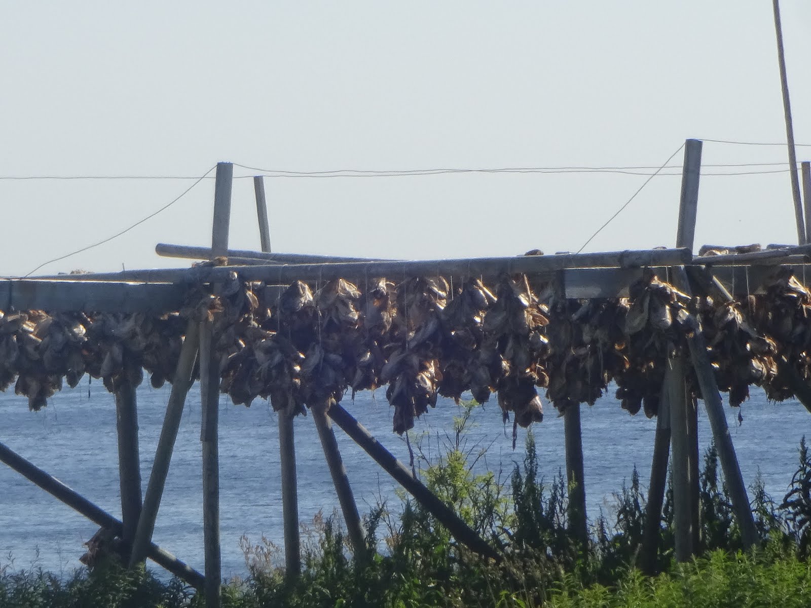
It seems that the fishes pearly white tongues are considered a culinary delicacy and these are often harvested from the hanging fish by local children who can sell them for 50 Nok (£5) per kilo! Apparently some of the entrepreneurs start their collections from the very young age of about 6, but as they get a bit older and become more proficient they can easily make 1,000 Nok in an afternoon and up to 50,000 Nok in a good season!!! I read that locals go wild for the tongues which are often served breaded and fried to resemble large scallops! And what's more, is the fact that there's always plenty to go round because Skrei is the world's largest cod stock and it's estimated that the Barents Sea contains about 1.7 million tonnes of them and Norway pulls about 340,000 tonnes of these fish out of their waters each year!
Saturday 21st July 2018 ⛅⛅☂☂⛅☂⛅
Mileage 36 from a wild camp spot at the side of the E10 near Varied to a motorhome parking area near Eggum
Parking Co-ordinates 68.307, 13.651
Oh dear, today was another one where we had a bit of a false start. We'd decided to visit the nearby beach and mountains of Haukland on the north side of the islands, but when we arrived every spare space was occupied because there was an 'event' on! So once again we found ourselves backtracking and aiming for the next place on our list which was Eggum which lies on the seaward side of Vestvagoy island. To get to the motorhome parking area which lies between the ocean and the mountains we needed to pass through the fishing village and traverse along a short section of unmade road, and although it was quite busy there when we arrived there was plenty of space for all so we quickly decided that this would be home for tonight.


Apparently the area is very popular because it's an excellent place to view the midnight sun - but I'm not sure if the weather is going to co-operate with that. However, for us it's provided a lovely 6ish mile coastal walk and we were also able to see the Eggum Head which is an artwork that looks out over the sea with the top either up or down depending on the angle from which you view it.


Tomorrow will probably be our last day on the Lofoten Archipelago and one where we plan to go and meet one or two Vikings!! After that we'll be heading off to Lodingen to catch a ferry to Bognes, and from there we'll be following the Helgeland coast southwards - but that will be another story.
Bye for now 😙😙
Click here to see our Norwegian Camping Spots
hi you two. i found this interesting it may be useful to you
ReplyDelete.https://www.theguardian.com/travel/2018/jul/22/norway-coast-fjords-road-trip-arctic-circle-holiday