Mileage 130 from Butterley Bank at Swanwick to Woodhill Park Campsite near East Runton
Parking Co-ordinates 52.93714, 1.26253
After lots of farewell visits with our family and friends (along with a few tears) we finally got back on the road and started our long awaited migration to the warmer climes of Spain. But before crossing over the water from Dover to Calais we'd decided we'd have a little holiday in North Norfolk so today's destination was Woodhill Park Campsite near East Runton where we'd managed to bag 4 nights for the price of 3😀.
Our journey down was happily completely uneventful but maybe a tad slow because we mainly followed 'A' roads and we often found ourselves behind large lorries or other crawlie vehicles! However, we made it in 4 hours and well before dark so we weren't complaining.
Friday 9th November 2018 ⛅⛅⛅⛅⛅⛅
👣👣About 8 walking miles from the campsite first to Cromer and then on to Overstrand.

Once we were on the coastal path it very quickly led us into Cromer where, as we walked, we found plenty to interest us, and from our lofty position high up on the cliffs overlooking the sea we had wonderful views looking both west towards Sheringham and east towards Overstrand (which was to be the furthest point of today's walk). Apparently, at this point we were also overlooking the lost village of Shipden - a village which was claimed by the sea way back in the 14th century, but it's said that some of the remains of the church sill exist beneath the waves - or at least they did in 1888 when a steamer heading for Cromer sunk after hitting the submerged Church tower! And spookily, even today some of Cromer's residents claim they hear the water logged bells ringing on still nights👻👻!
 |
| Cromer Pier from one side |
 |
| and the other! |
 |
| Apparently in Cromer the Town Council don't use lawnmowers - They use Bagots instead! The herd are both a tourist attraction and a land management project for the grassy slopes that lead up from the sea! |

 Further along still we passed numerous brightly painted beach huts and we also paused to watch several 'crabbers' bring in the catch for which Cromer is most famous! By all accounts the fishing industry in this area has declined but even on this blustery November day the boats were still being launched from the beach so that the many off shore crab and lobster pots could be tended to!
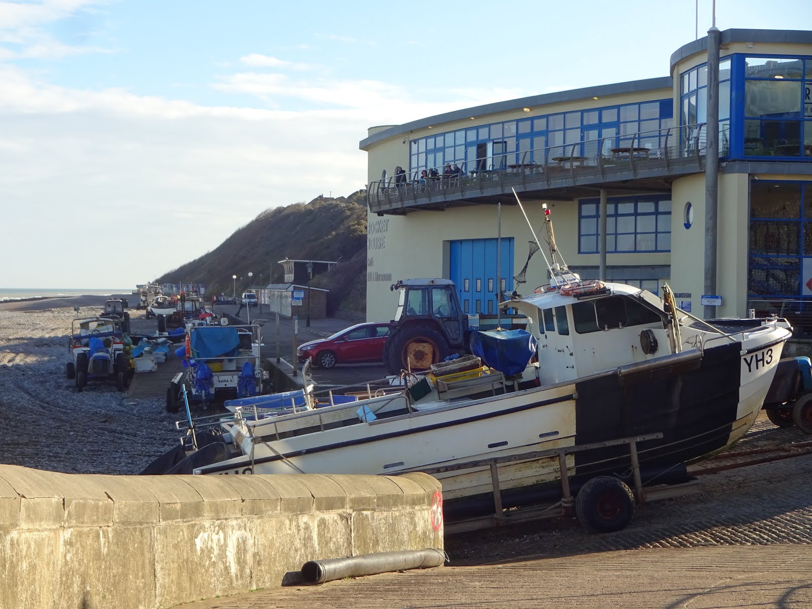 |
| Crabbing Boats and Tractors on the Beach |

As we proceeded along the sea front we passed by a museum that was a tribute to one of the most famous coxswain's of this area - Henry Blogg (1876 - 1954). He was the RNLI's most decorated lifeboatman and during his 54 years of service he and his crew launched their boats 387 times and helped save the lives of 873 people!
After that we continued along the beautiful coastal path with the sea on one side and low flying golf balls on the other as passed by the huge golf links that lie between Cromer and Overstrand! But happily we made it without having to deflect any stray spherical objects, and once we reached our destination we had to make a very hard decision! And that was 'where were we going to eat'. Should it be in the posh Gourmet White Horse Pub or should we choose the Cliff Top Cafe with it's marvellous sea views??? We chose the latter but our decision making didn't stop there because the menu had a huge range of dishes to tempt us, but in the end we both settled for 'Moby Dick' and chips - and needless to say after that lot we didn't need any tea!!

With our appetites well and truly sated we staggered out and headed back the way we'd come, but this time rather than sticking to Cromer's coast we wandered up into the town and one of the things that this allowed us to admire was St Peter & Paul's Church which was built between 1377 and 1437 to replace the one that had been lost to the sea at Shipden. It's 160 foot tower dominates Cromer's skyline, and as it's the tallest tower in the fairly flat county of Norfolk it can be seen for many miles.

We concluded out walk by trekking back the way we'd come, but we did make a slight detour to Morrison's - and I'll blame John for that!! He'd missed his pint at lunch time so insisted we buy a 'takeaway' one to enjoy when we got home, and because he twisted my arm I had to join him in this little indulgence or two🍻😆!
Saturday 10th November 2018 ⛅⛅⛅⛅⛅⛅☔☂
👣👣About 8 walking miles from the campsite to Sheringham and a bit beyond
Well, the wind had howled and the rain had pounded down last night, but this morning we woke to bright and very breezy sunshine, and at least we'd been spared the pummelling that the other side of the country seemed to have endured!
 We had thought we might go out on our bikes but because it was still quite windy we settled for another walk - this time in the opposite direction to Sheringham. Once again we toddled along high and crumbling cliff paths where free helicopter rides were advertised, and some folks seemed quite keen to accept them because they had scrambled through the fencing and were standing directly over the crumbling protruding shelf like clumps with only a long way down beneath them.
 Our trail continued on for about 3 miles towards Sheringham, but just before we got there we had to pass over The Beeston Bump which rises 63 metres above the sea and which was originally deposited at it's present site during the last Ice Age. The Bump was used as a 'Y Station' for signalling and intelligence purposes during the last war, and legend has it that it's also the lair of the Black Shuck - a terrifying hound that roams the hills of Norfolk. Happily, we didn't see him because the legend also tells that if you do your sighting is a precursor to death⚰️! However, on our return journey a fox did cross our path, but rather than this having any sinister implications it just enhanced our pleasure in our walk
 |
| The Beeston Bump |

 |
| A mural painted by David Barber in April - May 2016 depicting a scene from 30,000 years ago and included mammoths, sabre toothed cats, rhino, giant deer and a Neolithic Village. |
The street art also included Einstein enjoying a coffee and quite a few other bronze etchings that depicted the towns history.

 |
| The View from today's picnic site |

We chose another drafty spot for our picnic lunch at a lookout station that is ran by volunteers and lies just beyond the town of Sheringham. The site is linked to the RNLI and it seems it's been a saviour on more than one occasion, and the benches outside provided a comfy place for us to lap up more fantastic coastal views before we retraced out steps back down in the bustling busy seaside town's streets. Here we found quite a few of the usual high street names, but also lots of little unique curio and antique outlets - Hey Mum, I think the buyers from 'Flog it' ought to come here to try their luck!!😂😂

We explored the main street up as far as the train station where we found the Saturday Market just packing up, and although we were tempted by some of the very tasty goodies on display we abstained because we'd still got 3 miles to walk home and we didn't want to increase our load.
Our return journey was completed by just after 3pm and it wasn't long after that when more rain gently pitter pattered on our roof but as we were snug inside T4rdis2 it really didn't matter.
Saturday 11th November 2018 ☂⛆⛆☔⛅⛅⛅⛅⛅
About 8 🚴🚴 miles and 3 👣👣 miles.


On this, the Centenary of Remembrance Day our Son in Law Paul and Grandson Thomas made us very proud as they prepared to pay tribute to all those who fought and paid a huge price for the freedom of our country.
But back at the ranch we couldn't quite decide what to do with ourselves because initially rain stopped play! However, that gave me chance to do our laundry, and by the time that was finished the sun was trying very hard to show it's face.
 Therefore we decided to allow our bikes to escape from our garage and take us for a ride to the National Trust's Felbrigg Hall, and even though the Hall itself was closed we still very much enjoyed our stroll around the grounds.
 |
| Felbrigg Hall |

And then once our blustery walk was done we broke with our usual habit of partaking of our own coffee, and instead visited the Squire's pantry for delicious coconut and fruit flapjack which we washed down with 2 creamy latte coffees taken outside in the courtyard in what was now quite warm sunshine.
After that we cycled back into Cromer and munched our picnic lunch on the pier while being amused watching the starlings and gulls compete for peoples left over fish and chips! And then it was only a short but chilly peddle back to T4rdis2, because by that time, the sun was very low in the sky and a cold wind was whistling full pelt towards us!
Monday 12th November 2018 ☂⛆⛅☔⛅⛅⛆⛆⛅⛅
Mileage 188 from Woodhill Park Campsite in North Norfolk to Park and Ride Aire near Canterbury
Parking Co-ordinates 51.26154, 1.09988
This morning we left Woodhill Park Campsite and completed our journey down to the Canterbury Park and Ride Aire, and once again our trip was quite uneventful! On our way we stopped for shopping and refuelling, and other than the traffic slowing as we passed over the Dartford Crossing we made reasonably good time and landed at our destination around 4pm. Then once we'd settled, one of our first jobs was to pay our toll on line - a task that was thankfully very simple!
Our ferry over to Calais leaves Dover at 11.10 tomorrow, and at the mo the weather forecast looks quite peaceful🤞. Therefore our plan is to enjoy a full English as we sail away from Blighty's shores, and if the aforesaid prediction is true there should be no risk of regurgitation on the way.
Once we're in France we've got about two weeks to meander our way down to Southern Spain where hopefully we'll find lots of lovely sunshine to warm us through the winter months.
Bye for now 😚😚
No comments:
Post a Comment