Wareham Forest Tourist Park - Days 15 - 21 of our Autumn/Winter Tour
Monday 27th September 2021 🌞🌞🌞🌞🌞 ☂⛅
Today we aimed our car towards The Purbeck Hills, but more specifically, at the National Trust's car park at Studland from where we planned to walk to Old Harry Rocks, and then on a bit further to the Obelisk.

Once there we coughed up our £5 parking fee and then paused to admire the wide sandy beach that stretched away from us in both directions before we pottered along deep sandy paths to find the entrance to the coastal path. Then it was upwards and onwards past several concrete structures that are relics from the war, and then out onto the more open cliffside from where we had fantastic views of Old Harry Rocks and almost the entirety of Studland Bay.

The Bay was gifted to the National Trust in 1981 by Henry Ralph Bankes as part of the estates of Kingston Lacey of Corfe Castle, and at the time it was the richest ever gift to the National Trust. The info boards told us that in the early 20th Century Ralph enjoyed summer holidays at Studland Bay with his sisters Daphne and Viola and his Mother Henrietta who was widowed when he was only 2 years old
Initially on our walk the Old Harry Rocks was somewhat hidden from our view by low bushes and stunted trees but after a bit more than a mile the white chalky rocks came into view in all their glory and we were able to watch the waves swashing through the 2 arches of the largest one.


The rocks are made up of three chalk formations that include a stack and a stump, and are located at Handfast Point which is the most eastern point of the Jurassic Coast UNESCO World Heritage Site. And the name?? Well, as you would imagine there are various stories about how that came about. One legend tells how the Devil (who used to be called 'Old Harry') used to sleep on the rocks, and another suggests that the rocks were named after Harry Paye - a famous Poole pirate who used to hide his ship behind the rocks awaiting passing merchantmen. Then yet another tale tells how a Viking raid was thwarted by a storm and that one of the drowned was Earl Harold who was turned into a pillar of chalk!

We sat and picnicked on a ledge overlooking the rocks and from our vantage point we could also look over and just make out the chalky cliffs and Needles of the Isle of White.

Once fed and watered we set off again over Ballard Down and followed part of the Purbeck Way to the Obelisk which is a towering hexagonal monument. But at that point our walk turned into a bit of a battle because we were walking steeply uphill and directly into the strong wind - it almost felt like a natural CPAP ventilation machine as the powerful gusts forced the lovely Dorset sea air down into our lungs 😂. However, our distraction from that was the fantastic views that we were 'forced' to gaze at over Poole Harbour.
 |
| The Mouth of Poole Harbour |
 |
| And some of the more than 14 square miles that it's waters cover! |
Apparently Obelisks of this type often stand over important graves but this one was brought from London to commemorate the provision of a new water supply to Swanage in 1883.

However, in 1941 (during WW2) it was taken down for fear that it might act as a navigation aid for enemy aircraft, but later in 1973 it was re-erected and is now a Grade II listed structure.

 |
The Obelisk marked our turning back point and from there it was mostly downhill all the way back to the National Trust Visitors Centre, and as we went we debated whether or not to re-join the Trust. We've been members before but because we used to spend so much time abroad we let our membership lapse, but now because we're planning on staying within our own shores for the time being we decided it would offer us a lot more choice in things to see and do.
Tuesday 28th September 2021 🌧️🌧️⛅⛅⛅🌧️🌧️🌧️
Today started bleak and windy but by 10ish the sun was peeking out. However, the forecast for the afternoon was grim, so that, along with the issues concerning fuel shortages persuaded us to stay local for a walk and then to get a jigsaw our for our afternoons entertainment!


Wednesday 29th September 2021 ⛅⛅⛅🌞🌞⛅⛅⛅⛅
Today turned out to be another lovely mostly sunny day but unfortunately we couldn't take the best advantage of it because I had an appointment for my booster Covid jab booked at a Mass Vaccination centre in Boscombe. My appointment was at 10.45, but to say the least, the newly opened facility was a bit disorganised and what should have been a quick job took over an hour! Then we had food shopping to do so by the time we got back to our van it was nearly 2pm. Therefore, our plans to visit Corfe Castle were shelved and instead we decided to go for a wander around Wareham's ancient city walls and a walk down by the River Frome
Wareham town walls were originally built in Saxon times to defend Wareham from the Vikings but today only stumpy grassy mounds are left so it was quite hard to imagine what they would have looked like back in the day!
 |
| It almost looked like a Dutch Dyke rather than anything used for defence! |
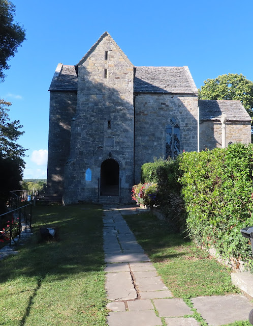
Part way round we came across the 11th century St Martin's Church which is said to be the most complete Saxon Church in the country and one that has served as a Parish Church for over 1000 years. Additionally, after The Great Fire of Wareham in 1762 a number of homeless families lived in the building so a fireplace was built in the nave for warmth and cooking and it's chimney can still be seen on the roof today!

It was hugely overgrown with tall reeds that almost completely obscured our views of the river, and although some attempt had been made to cut the reeds they'd all been left lying on the path and thus it was difficult to watch your footing on the very uneven and sometimes muddy ground. Added to that nettles and brambles had to be waded through and that wasn't so bad for me because I had long trousers on but John only had shorts so he was well and truly 'nettled' by the time we got to the other end! And to make things worse we hardly had time for our coffee and cake break before we had to dash back to the car park!
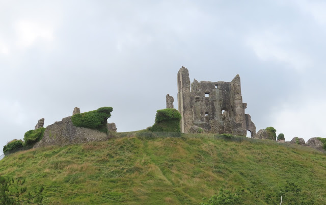
The Castle sits high atop of a hill overlooking the ancient village of Corfe and history tells how the Castle survived the English Civil War, but then how it was partially demolished by the Parliamentarians in 1646. However, later when we looked around the village it seemed that much of the stone from the demolition had been put to good use in the buildings there.

The Castle itself has been part of the Purbeck landscape for almost a thousand years and it was originally built by William the Conqueror in the 11th Century, and the info boards informed us that it then remained a 'Royal Castle' until the reign of Queen Elizabeth I, but she eventually sold it to Sir Christopher Hatton for the princely sum of £4,762, and after that it became a stately home!
 |
| Our Views as we walked up through The Bailey |
 |
As we pottered up towards the Keep we were afforded views of the draw bridge and gateway which has split down the middle with the left side much lower and further forward than the right. |
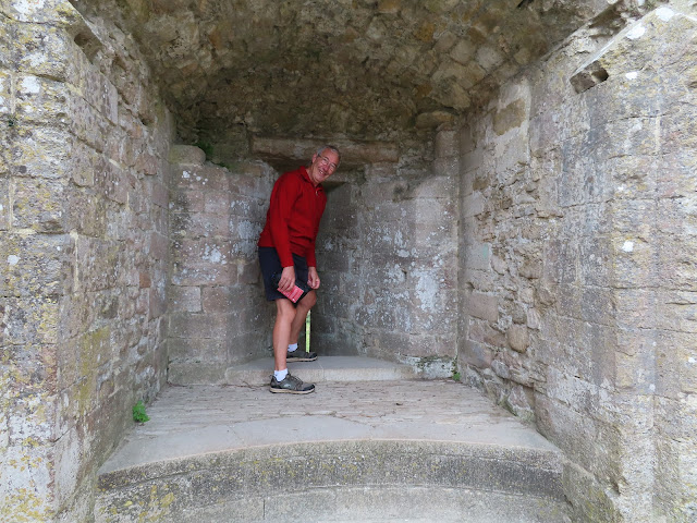 |
| The Third Tower with John having a peep out of one of the arrow slits! |
 |
| And this part of the Keep was refereed to as Twelfth Century Skyscraper! It stands 80 feet high on top of a hill that rises to 180 feet! |
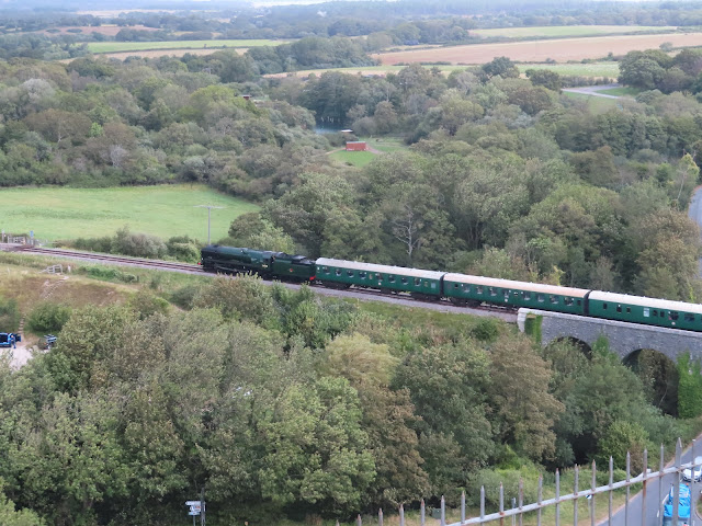 |
| We saw an old Steam Train Chuffing along the Swanage Line |
 |
| And we had magnificent views of the Purbeck Hills were we plan to do more walking soon. |

The Castle finally came into the care of the National Trust in 1982 along with surrounding countryside, coastline, farms and the mansion at Kingston Lacy which we will probably visit on another occasion.


 |


The views were quite mesmerising and we really could have sat and watched the riotous wave formations for hours. But after a good rest (along with a cup of coffee and a hot cross bun) we started our return journey, but this time instead of following the Coastal Path we climbed to a much higher level and followed a path that on one side overlooked the English Channel and on the other mostly open moor land.
 |
| Durlston Castle |
Saturday 2nd October 2021 🌧️⛆⛆🌧️⛆⛆🌧️⛆⛆🌧️🌧️
 |
| Its coming on 😂 |

 |
| You might get some idea of how high we were because in this pic we were looking down over Corfe Castle |

Our walk took us along a ridge that undulated over open grassland taking in West Hill, Knowle Hill and Ridgeway Hill, and provided us with stunning views over Poole Harbour and later out towards Weymouth and Portland. Our ultimate goal was folly called Grange Arch that is also known as Creech Folly. It was built in 1746 on what is the second highest point of the Purbeck Hills (Ridgeway Hill), and it stands in alone right in the middle of no where and it certainly isn't quite what you expect to see when your out hill walking!
 |
 |
| It's not quite the same picture - Can you spot Wally 😂😂😂 |
Fab pix and interesting read. Done more just west ... added to my list.
ReplyDelete